| 3,390 files in 44 albums with 0 comments viewed 100,214 times |
|
"Epic White Cloud Backpacking Loop" revisited (again!), August 19, 2024
|

|
|
|
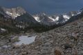
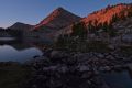
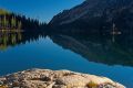
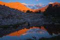
This demanding cross-country loop always has some surprises, and this year was no exception. Early Monday morning, shortly after I drove through, the Wapiti fire closed Route 21 near the Grandjean turnoff. Smoke from this fire stayed well northwest of the loop I hiked. It was the clearest I've seen it in years. The NOAA weather report indicated it would be 'breezy' the day I crossed the saddle between WCP-9 and D. O. Lee Peak. I've never experienced winds as strong as I encountered climbing to the saddle. It was not as frightening as the lightening storm I encountered here four years ago. There were no mosquitoes this trip, and unfortunately, no mountain goats or bighorn sheep. There was also less water; once more I failed to locate the stream around 8700' in Iron Basin. The perennial snowbank was no longer on the southwest bank of Cove Lake. The lake had more algae. There was much less water flowing into Cirque Lake from the east, as well as the stream coming in from the waterfall to the west. The fly-fishing was very rewarding. As usual, I walked out with a lot of food!
132 files, last one added on Sep 09, 2024
Album viewed 3 times
|
|
|
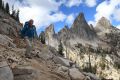
Imogene Lake, Mt. Cramer, October 5, 2023
|
|
|
|
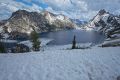
I had day hiked to Imogene Lake in September 2009 and have wanted to return ever since. A week of beautiful weather provided a window of opportunity to visit this area once more. I fly fished the lakes above (southwest) of Imogene. After acclimating for a day or two, and allowing a light dusting of snow to dissipate, I climbed Mt. Cramer, the second highest peak in the Sawtooth at 10,716. Skies were clear, with daytime temperatures well into the 50's and lows at the freezing mark. This was the first time I have done a multi-day trip this late in fall. This is a very popular destination. Fewer people and fall color convinced me to head into the high country before the snow falls in earnest.
56 files, last one added on Oct 16, 2023
Album viewed 8 times
|
|
|
"Epic White Cloud Backpacking Loop" revisited, August 27, 2023
|
|
|
|
With monsoonal moisture from Baja California producing thundershowers over Idaho's mountains I pushed off this trip almost a week. Fortunately, lightning did not cause fires in this area. A five day window opened just before Labor Day weekend with unseasonably warm temperatures the first three days, becoming unseasonably cool the last two days. No smoke drifted in from fires out of state. This is a challenging route, and navigation the first day out can be tricky without GPS. Aside from difficulty locating a stream in Iron Basin, things went smoothly. I saw two mountain goats in Iron Basin, and had some great fly-fishing in the Big Boulder Lakes Basin. I encountered fewer people in the Big Boulder Lakes Basin, but more than expected in the Boulder Chain Lakes basin. I was using a shoulder strap mount to keep my camera accessible, so I took more photos, especially climbing in places where I would not have wanted to take my pack off!
126 files, last one added on Sep 11, 2023
Album viewed 15 times
|
|
|
|
"Epic White Cloud Backpacking Loop" revisited, August 16, 2022
|
|
|
|
I started this backpack a week earlier this year; more water, less smoke, and hopefully, more wildlife. There were more mosquitoes, but I didn't anticipate seeing more people. That was OK after not seeing a soul the first two days. I enjoyed meeting all of them. A navigational error finding my way into Iron Basin cost me a day, but the more challenging terrain ahead went smoothly. The last three days cooled off nicely with the arrival of thundershowers. With a 20 to 30% prediction from NOAA, I was expecting rain; it wouldn’t be the White Clouds if it didn't thundershower. Fortunately, I was not crossing any high ridges when the lightning show began, as was the case two years ago. I didn't see the bighorn in Iron Basin this time, but I was rewarded with 5 mountain goats bolting down from the D. O. Lee/WCP-9 saddle to within 50 yards, as I reached the top of the stream cascading toward Cirque Lake east of the saddle. Fly fished the lakes in Big Boulder Lakes Basin, and a few of the Boulder Chain Lakes. Any time I can have trout for dinner, it's a great day of fly fishing!
60 files, last one added on Aug 28, 2022
Album viewed 31 times
|
|
|
Sawtooth Lake loop via Trail Creek, North Fork Baron Creek, Grandjean Idaho, July 9, 2022
|
|
|
|
This is the fourth time I've done this roughly 20 mile day hike, with a respectable 4K foot gain. It has become a yearly tradition since 2020. The first time in 2013, my girlfriend and I were only planning an easy hike to Trailside Lakes. After a refreshing swim, I suggested doing the entire loop after seeing the route on the display at the trailhead. It was a hot day, and I was in no hurry to get back to the 100 degree temperatures in Boise. I knew we’d be finishing well after sunset. Reluctantly, she agreed. As we started losing the light, I was completely caught off guard by the challenge of crossing the North Fork of Baron Creek. This time, the late season snows made this crossing more challenging than usual. It was probably a good thing nobody I asked, was able to join me on this particular hike.
33 files, last one added on Jul 12, 2022
Album viewed 21 times
|
|
|
So-called "Epic White Cloud Backpacking Loop", August 24, 2020
|
|
|
|
Documented in Idaho Alpine Zone, I have been wanting to do this loop for several years. I was intrigued by the big horn sheep population (not to mention the mountain goats) in the basins west of the high point, a saddle between WCP 9 to the north, and D. O. Lee Peak just south. Two years earlier, from this same saddle, I had peered down to the west thinking it did not appear as difficult as described. On that trip, I had crossed from the more northerly Big Boulder Lakes into the Boulder Chain Lakes Basin via, what a woman leading a sizeable group of young people into the latter basin from the east, termed the “Cheese Grater”. I had never utilized the “Devil’s Staircase”, which easily trims a full day of hiking by avoiding a descent to Quiet Lake, and a climb into Four Lakes Basin. Viewing the steep scree chute from Born Lakes had convinced me it was not something I wanted to try solo. I was pleasantly surprised, despite the intimidating name. The loop proved to be challenging, especially due to weather, and extremely rewarding with exceptional views, a plethora of wildlife, and splendid fly fishing.
79 files, last one added on Sep 21, 2020
Album viewed 25 times
|
|
|
Big Boulder Lakes, Boulder Chain Lakes loop, September 6, 2018
|
|
|
|
My intent was to do the trip posted on Idaho Alpine Zone the author referred to as, “Epic White Cloud Backpacking Loop”, but a fire to the south closed the Fourth of July Lake trail, which is key to completing that loop. I saw that a loop could be made by crossing from Cove Lake in the Big Boulder Lakes basin to Hummock Lake in the Boulder Chain Lakes Basin as described in the Epic White Cloud Backpacking Loop and returning to the Livingston Mill trail head. The trip proved to be an adventure—too adventurous for a friend who bowed out. Once more, I went solo, experiencing a thunderstorm with lightning the first night out, an encounter with a mountain goat, some great fly fishing, and a windy climb up D. O. Lee Peak. The scenery is spectacular. With the exception of Hummock Lake, and the first couple of miles out of Livingston Mill, this is terrain I had not yet visited.
75 files, last one added on Oct 18, 2018
Album viewed 17 times
|
|
|
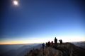
Eclipse from Thompson Peak, August 21, 2017
|
|
|
|
Thompson Peak, highest in the Sawtooth National Recreation Area, rises dramatically above Stanley, in the path of totality. My intention all along was to be within this path, a mere 2 hour drive from my home. I decided to post this hike on a local Meetup Group, “Idaho Hiking Club” in the hope of finding others who wanted to witness this phenomenal event up close. Surprisingly, only one other person signed on. That may have been due to a day hike to Goat Lake organized just a few days earlier described as ‘strenuous’; our trip was a four day backpack, with a destination well beyond Goat Lake. I was designated as ‘leader’, a position I am more than happy to let someone else shoulder. Then I learn it is the first backpack for the person who is to join me. In my description, I did state, “This is a beautiful basin, and is not that difficult to reach.” I am very good at underestimating the difficulties in getting to places I want to visit again and again. I stressed the need to travel light, and did not even plan to ascend Thompson Peak. The hike would “unfold on a daily basis”. It unfolded rather nicely…
69 files, last one added on Sep 01, 2017
Album viewed 63 times
|
|
|
Bighorn Crags, September 2, 2016
|
|
|
|
After driving 50 miles on dirt roads, with the promise deteriorating weather and a few hours of sleep the night before, we began the steep trek about 1 pm. Just after passing Cathedral Rock, we discovered to our delight, and also consternation, the map I had prepared using TOPO!, complete with waypoints, failed to show the most efficient route, now the main trail to our destination. Not only was it clearly signed, but there it was on map we had just happened to pick up at the trailhead which showed another trail closure due to a fire. The good; Birdbill Lake, our destination was less than 8 miles from the trailhead, a full mile less than the route on my map, which descended to Wilson Creek. The bad; the shorter route climbed to a higher elevation, and was bone dry until it reached Birdbill Lake. Fortunately, we were each carrying 2 liters of water. The waypoints on my map were of little value, as we elected to leave the GPS behind, due to weight considerations, even though we were expecting snow by the end of the trip.
61 files, last one added on Aug 28, 2017
Album viewed 20 times
|
|
|
Boulder Chain Lakes, September 8, 2015
|
|
|
|
An unseasonably cool cold front arrived just in time for the Labor Day weekend, leaving a fresh dusting of snow high on Castle Peak. Still recovering from oral surgery, I was more than happy to push this trip off until Tuesday. Traveling solo always means shouldering more weight, but I tossed in the DSLR, 3 lenses, and the extender, bringing the weight to the level of absurdity. I was able to go with less clothing, as the weather was predicted to improve dramatically. I did not expect to see many people back there, but I was wrong. I even played leapfrog with a large party who had started on the east side, but exited via the same route I came in, most of which was cross country beyond Born Lakes. I made up time after a late start, and stayed with the plan. The route presented some unexpected challenges, but was very reasonable for the most part. Out a full four nights, I would not have minded another day to try fly fishing a few more of the lakes. An impressive trip I would like to do again-- with less weight!
85 files, last one added on Aug 28, 2017
Album viewed 17 times
|
|
|
White Clouds; Castle Peak Loop revisited, August 29, 2014
|
|
|
|
Since taking up fly fishing once again the year before, I was eager to fish the lakes on this loop after reading someone's post in answer to a question regarding the best places to fish. It was obvious to this person that the Boulder/White Clouds were far superior to the Sawtooth due to trout species inhabiting the various lakes, and especially because the lakes in the Boulder/White Clouds see far less visitation. We visited Ant Basin and the Born Lakes, Four Lakes Basin, Quiet and Noisy Lakes, Baker Lake, Castle Lake, Chamberlain Basin, Washington Lake, and finally, Fourth of July Lake, fishing all except the last two, and Baker. I was not disappointed, landing a nice trout on my very first cast with a new fly rod at the second highest of the Born Lakes. Unfortunately, while fumbling to get a second fish on the stringer, the first trout managed to swim away, trailing the stringer from his gills. Had I not had my boots on, I would have dove into the lake in pursuit!
67 files, last one added on Sep 20, 2014
Album viewed 18 times
|
|
| 43 albums on 4 page(s) |
1 |
|
|
|
|

IMG_8915.JPG1 viewsOn the ridge northwest of Echo Lake.
|
|

IMG_9197.JPG2 viewsThe dark clouds in the background make the direct orange sunlight hitting the peaks even more dramatic.
|
|

DSCF0484.JPG4 viewsMy campground is minutes away down a grassy slope; no more boulder-hopping. I'm thinking the far side of Hummock Lake, where I read there is a "primo" campground.
|
|

IMG_2035.jpg97 viewsPartial eclipse; D. O. Lee Peak.
|
|

IMG_9984.JPG0 viewsLooking south across Donelson Lake.
|
|

DSCF0489.JPG3 viewsI have what must be the "primo" camp spot to myself. I has been stocked with plenty of wood, in the event I catch some trout. It is now almost 6 pm, so I have plenty of time to set my hang for the food, get the tent set up, pump water, fish, and make some dinner-- in the light!
|
|

IMG_5526.JPG10 viewsErratic in stream east of Flatrock Junction.
|
|

IMG_6670.JPG10 views
|
|
|
|

DSCF1097.JPG2 viewsThis tarn is at an elevation of 9730', well above Fourth of July Lake. The water is a bit brackish, but will do in a pinch. I hear from more than one party ascending from the Fourth of July trail head that the road from Stanley to Grandjean was is still closed. I'm making good time, and will be able to make the most of the remaining light, getting to Ketchum just as it is getting dark. I reach the trail head at 7:30 pm, completing the "epic White Cloud backpack loop" for the fourth time.Sep 09, 2024
|
|

DSCF1095.JPG2 viewsFourth of July Lake to the S.Sep 09, 2024
|
|

DSCF1094.JPG4 viewsDescending toward Fourth of July Lake from the top of the ridge SW of Ants Basin, looking W across the Sawtooth Valley. One can see the smoke from the Wapiti fire S of Stanley on frame right (N). Yesterday I was told the road from Stanley to Grandjean was still closed. I'm hoping that has changed, but not counting on it.Sep 09, 2024
|
|

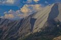
DSCF1093.JPG1 viewsShadows drifting across the face of WCP-8 (10557') from the top of the ridge SW of Ants Basin. (58 mm)Sep 09, 2024
|
|

DSCF1089.JPG2 viewsThe familiar orange band I navigated toward the first day to the trip descending Strawberry Basin to Warm Springs Creek from the top of the ridge SW of Ants Basin. (200 mm)Sep 09, 2024
|
|

DSCF1087.JPG1 viewsWCP-8 (10557') from the top of the ridge SW of Ants Basin. (95 mm)Sep 09, 2024
|
|

DSCF1086.JPG1 viewsThe pinnacle immediately S of the Devil's Staricase from the top of the ridge SW of Ants Basin. (200 mm)Sep 09, 2024
|
|

DSCF1084.JPG1 viewsWCP-8 (10557') above the Warm Springs Creek drainage. The constantly changing light and shadow drifting across the limestone face provide photo opps.Sep 09, 2024
|
|