| 3,390 files in 44 albums with 0 comments viewed 100,215 times |
|
Lost River Range, Merriam Lake, Leatherman Pass, Pass Lake September 5, 2011
|

|
|
|
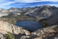
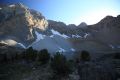
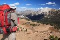
A longing to cross the Lost River Range, venture into the Pahsimeroi Valley, and beyond to the Lemhi Range, was finally fulfilled Labor Day weekend of 2011. Northwest of Mackay, we ascended Doublesprings Pass Road to the summit, then headed off southeast on increasingly rougher roads over Horseheaven Pass to the Merriam Lake trailhead in Upper Pahsimeroi Valley. There was one other truck and several ATVs at the end of the rutted 4WD road. We hiked to flower strewn meadows above Merriam Lake in the late afternoon, returning just after sundown. To our delight, every vehicle had vanished, and we had a tranquil, streamside base camp to ourselves-- astonishing for Labor Day! A great breakfast was an agreeable tradeoff for our late start the next morning up to Leatherman Pass. We had entertained thoughts about doing the peak, but the almost noon start was certainly instrumental in deciding against it. The bigger factor was the unaesthetic steep, loose, talus slope climbing the west ridge from the pass. We opted to retrace our steps, lose a few hundred feet, and contour west, cross country, over to Pass Lake. The side trip involved some boulder hopping, but proved to be well worth the effort. The remaining daylight vanished quickly exploring and photographing the lake basin. The trail down was easy to follow in the fading light. Another gourmet dinner on the coals of a campfire; definitely something to be said about hiking light, and enjoying the comforts of car camping in a remote area. The next day we descended into the Pahsimeroi Valley, and down Little Lost River Road, following the western flank of the Lemhi Range. After exploring Barney Hot Springs, we turned northeast and headed up Sawmill Canyon Road to Mill Creek Campground. As it was Labor Day evening, and most visitors to this remote area were already headed home; we were the sole occupants. The next morning we hiked to Mill Creek Lake. It is always interesting to hike in a place one has not been, but I definitely preferred the previous days' scenery. We drove down Little Lost River Valley Road about one mile and turned south onto Dry Creek Road, following it to its intersection with Pass Creek Road. Unsettled weather afforded dramatic views of Bell Mountain to the northeast. From Pass Creek Summit at the crest of the Lost River Range, the Big Lost River Valley is seen to the south with the Pioneer Mountains rising beyond. From here, the road drops down through Pass Creek Canyon, which Tom Lopez (Idaho, a Climbing Guide) considers, "one of the most striking gorges in the state."
118 files, last one added on Jan 24, 2012
Album viewed 31 times
|
|
|
Yosemite, North, July 17, 2011
|
|
|
|
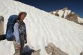
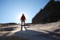
It had been a record snow year in the Sierra. I had been reading about arduous stream crossings in Matterhorn Canyon and the confluence of Virginia and Spiller Creek Canyons in internet journals of hikers traveling the Pacific Crest Trail. I prefer late August in the high country, but, once again, we were going to be in the area in mid July. I knew we would be encountering snow, but that could work in our favor, providing an easy route across talus covered slopes on the high, cross country part of our route, especially on steep Sky Pilot Col which we would have to cross to return to our truck-- that is unless we bailed out at some earlier eastside trailhead. We would be on trails from the Virginia Lake trailhead to Tuolumne Meadows, with a day hike up trail-less Spiller Creek Canyon. From Tuolumne Meadows, we planned to return to Virginia Canyon via Steve Roper's "Sierra High Route", a cross country alternative to the JMT that continues past Tuolumne Meadows, and finishes at Twin Lakes, southwest of Bridgeport. The loop trip would take 7 days and 6 nights.
198 files, last one added on Dec 17, 2012
Album viewed 8 times
|
|
|
|
|
Goat Lake, Thompson Peak loop September 4, 2010
|
|
|
|
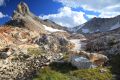
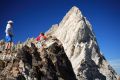
This is one of the most beautiful hikes I have done in the Sawtooth. It can be done in a long day, but we ended up getting back to the car close to 4 am! At least one third of the route is is cross country and requires good mountaineering and route finding skills, especially if you find yourself out after dark. We figured we would be fine if we descended from the "Unnamed Lake" below Thompson Peak, and reached the main trail in the last light. Alpine Way, beyond Marshall Lake sees very little travel, and proved to be a challenge in the dark. The lake basins above Goat Lake are spectacular. The final ascent into the basin south west of Thompson was probably the most technically difficult. Following close to the snow couloir proved to be the easiest. The steep benches that descend toward the "Unnamed Lake" east of Thompson are exposed in places and require careful route finding. The threatening weather provided great photo opps. Highlighting our late night excursion along Alpine Way were lightning strikes in the valley below toward Stanley. A rewarding, memorable hike. Take a headlamp and get an early start!
43 files, last one added on Jan 16, 2012
Album viewed 14 times
|
|
|
Warbonnet Lakes Basin revisted, August 20-22, 2010
|
|
|
|
Repeating a route I had done 3 years ago, Elisa (a.k.a. the Professor) and I took 3 days this time, and engaged the services of the Redfish Lodge transfer launch to shorten the hike by 10 miles. Nonetheless, we still found it to be an ambitious hike with little leisure time. The route is described in the gallery dated August 11-12, 2007. An approaching cold front resulted in spectacular cloud formations. High winds and rain at Packrat Lake kept us up much of Saturday night. Despite having done the route before, navigation down from Upper Redfish Lakes was still challenging. Hoping to make the 3 pm boat, we found ourselves practically running to make the last scheduled return at 7 pm. Of course, I always stop for photographs!
96 files, last one added on Aug 27, 2010
Album viewed 11 times
|
|
|
Yosemite; Lyell Fork, Merced River, Half Dome, Tuolumne Meadows, July 17, 2010
|
|
|
|
This is a classic Yosemite loop, all of which I have done in various order when I first began backpacking about the time I started college. Since my companion had never been to Yosemite, I suggested a route which would take us through the central, higher elevation terrain of the park. The route gently climbs south along the meandering Lyell Fork of the Tuolumne River before turning abruptly west, ascending to the head of the Merced River drainage. It descends through alpine meadows, past Merced Lake, and into Little Yosemite Valley, where there is now a huge backpack camp everyone is forced to stay in. She wanted to see the Valley, so we left our heavy packs and mandatory bear canisters above, and day hiked down the Mist Trail into the valley. We toured the valley via shuttle busses, had some ice cream, and hiked the Muir Trail back to our camp behind Nevada Falls, arriving in the last light. The next morning we headed up the Sunrise trail, stashed the packs, and ascended Half Dome. We camped along Sunrise Creek, about 8500', well before Long Meadow. We hiked past landmark Cathedral Peak the next day, and competed our loop by descending to expansive Tuolumne Meadows. A great introduction to the Yosemite high country!
131 files, last one added on Oct 07, 2013
Album viewed 8 times
|
|
|
|
|
|
White Clouds; Castle Peak Loop, September 16-19, 2007
|
|
|
|
The weather service was predicting a slight chance of rain/snow at 10,000 feet east of Stanley associated with a few upper level lows sliding into the area in close proximity. Nonetheless, we decided to embark on a relaxing 4 day loop that would take us into Ant Basin and the Born Lakes, Four Lakes Basin, Quiet and Noisy Lakes, Baker Lake, Castle Lake, Chamberlain Basin, Washington Lake, and finally, Fourth of July Lake. The weather presented spectacular displays, but quite a bit more precipitation than we were anticipating this early in the season.
65 files, last one added on Sep 22, 2007
Album viewed 9 times
|
|
|
White Clouds; Chinese Wall, August 25-26, 2007
|
|
|
|
As Mike Allen accurately put it, "This hike will be unique because we'll actually start at 10,400' at the crest of Railroad Ridge (4WD). The backpack will only be 2 miles long. The first mile will be fairly easy. The second mile will be difficult, as we will have to descend 300-500' of steep scree, but we'll take our time and scout the best way down...we'll have the option of hiking out down Gunsight Cr (2.5 cross country miles) to the trail, then 3.5 miles to the Trailhead" at Livingston Mill. Since 5 of us drove in one 4WD, Mike graciously offered to hike out the way we came so others could do the entire loop. Bighorn sheep were seen twice on this trip. As we neared the high point above Railroad Ridge, one band evaded the lens, disappearing south over the ridge. The next day, another, or perhaps the same band proved a bit more curious, and I was able to get several photographs before they vanished.
65 files, last one added on Aug 28, 2007
Album viewed 14 times
|
|
|
Redfish Lake, Pinyon Peak Lookout August 16-19, 2007
|
|
|
|
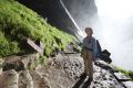
The waters of five mile long Redfish Lake lie in a U-shaped, glacially-carved valley, contained naturally by lateral moraines along its length, and a terminal moraine on the north end near the lodge. The Lake was once abundant with Sockeye salmon that battled upstream through the Salmon and Columbia River from the Pacific, returning to their birthplace to spawn. Seeing Sockeye in Redfish is now rare event primarily due to eight concrete dams that hinder their path. Kokanee salmon, a bright red smaller species of Sockeye, live out their entire lives within the lake, then swim up Fishhook Creek in mid August to spawn. We explored the Fishhook Creek inlet near the Visitor Center, but were too early to see any Kokanee spawning.
Pinyon Peak Lookout, elevation 9855', located atop Pinyon Peak, is the second highest of 196 that still exist in Idaho. Built in 1930, it is one of 60 that is staffed. We drove almost 23 miles on dirt roads to reach the lookout, crossing Marsh Creek northeast of Idaho 21, leaving the highway at the tip of Cape Horn.
47 files, last one added on Aug 30, 2007
Album viewed 8 times
|
|
|
Warbonnet Lakes Basin, August 11-12, 2007
|
|
|
|
My friend Fred and I backpacked cross country into Warbonnet Lakes from the north. The route is described in Lopez's 'Idaho, a Climbing Guide'. The following day we contoured above Blue Rock Lake, and ascended to a tarn between La Fiamma and Mount Underhill. Continuing south, we contoured above Packrat Lake, eventually crossing the main Sawtooth Crest at a saddle just north of Reward Peak. We descended northwest to Upper Redfish Lakes, joining the trail in the deep valley to the west, which crosses Redfish Lake creek just before Flatrock Junction and continues to Redfish Lake. This 2 day hike is reasonable if one takes advantage of the transfer shuttle, thus shaving off about 10 miles of easy hiking. Unfortunately, the boat was not available on the way in, and we missed the last shuttle by half an hour on the way out. Had we picked up the pace, there would most certainly be fewer photos.
63 files, last one added on Aug 14, 2007
Album viewed 8 times
|
|
| 43 albums on 4 page(s) |
|
3 |
|
|
|

DSCF1074.JPG1 viewsThe second highest of the Born Lakes. I've always caught trout here. It looks very inviting, however, it is supposed to get much cooler tonight. After five days, I'm ready to sleep in my comfortable bed.
|
|

IMG_4285.JPG5 views
|
|

IMG_3440.JPG18 viewsPhoto opps on the summit.
|
|

IMG_3211.JPG21 viewsThis was a nice place to stop for a snack and soak feet, as the most difficult section of the hike was behind us.
|
|

IMG_7561.JPG10 views
|
|

IMG_0967.jpg92 views
|
|

IMG_3192.JPG25 viewsWide view of the entire Pettit Lake drainage from the notch.
|
|

IMG_9683.JPG4 viewsFlowers, fog, sunrise; Echo Lake.
|
|
|
|

DSCF1097.JPG2 viewsThis tarn is at an elevation of 9730', well above Fourth of July Lake. The water is a bit brackish, but will do in a pinch. I hear from more than one party ascending from the Fourth of July trail head that the road from Stanley to Grandjean was is still closed. I'm making good time, and will be able to make the most of the remaining light, getting to Ketchum just as it is getting dark. I reach the trail head at 7:30 pm, completing the "epic White Cloud backpack loop" for the fourth time.Sep 09, 2024
|
|

DSCF1095.JPG2 viewsFourth of July Lake to the S.Sep 09, 2024
|
|

DSCF1094.JPG4 viewsDescending toward Fourth of July Lake from the top of the ridge SW of Ants Basin, looking W across the Sawtooth Valley. One can see the smoke from the Wapiti fire S of Stanley on frame right (N). Yesterday I was told the road from Stanley to Grandjean was still closed. I'm hoping that has changed, but not counting on it.Sep 09, 2024
|
|

DSCF1093.JPG1 viewsShadows drifting across the face of WCP-8 (10557') from the top of the ridge SW of Ants Basin. (58 mm)Sep 09, 2024
|
|

DSCF1089.JPG2 viewsThe familiar orange band I navigated toward the first day to the trip descending Strawberry Basin to Warm Springs Creek from the top of the ridge SW of Ants Basin. (200 mm)Sep 09, 2024
|
|

DSCF1087.JPG1 viewsWCP-8 (10557') from the top of the ridge SW of Ants Basin. (95 mm)Sep 09, 2024
|
|

DSCF1086.JPG1 viewsThe pinnacle immediately S of the Devil's Staricase from the top of the ridge SW of Ants Basin. (200 mm)Sep 09, 2024
|
|

DSCF1084.JPG1 viewsWCP-8 (10557') above the Warm Springs Creek drainage. The constantly changing light and shadow drifting across the limestone face provide photo opps.Sep 09, 2024
|
|