| 3,390 files in 44 albums with 0 comments viewed 100,215 times |
|
|
|
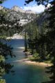
Redfish Lake and Stanley Lake, August 10, 2014
|

|
|
|
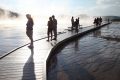
We sailed to the west side of Redfish Lake to camp overnight. The plan was to do some fishing, but after finding little information online, the proprietor at McCoy's Tackle Shop in Stanley gave us the bad news about fishing in Redfish Lake. By the time we got the sailboat in the water, there were no longer any whitecaps, just barely enough wind to get us to the other side-- not the first time this has happened. The next day the wind didn't come up at all and we all got some exercise paddling. Fishing was not much better on the Salmon, so we headed over to Stanley Lake. We arrived in the midst of a thunderstorm; not good for fishing, but great for photography!
8 files, last one added on Sep 24, 2014
Album viewed 11 times
|
|
|
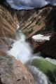
Yellowstone, June 27, 2014
|
|
|
|
Thunderstorms, rain and snow showers from a series of early summer Pacific troughs, brought nighttime temperatures into the mid-thirties. With a camper and reservations in Canyon and Grant Villages, the weather would only bring photo opportunities. If one thinks of the park as a huge figure eight, we did the upper loop in a counterclockwise direction on Saturday, and the lower loop in a clockwise direction Sunday. The early evening light was amazing. As usual, we ended up having late night dinners, sleeping later, and missing the early morning light. These trips never offer relaxation, but always reward with fantastic views.
185 files, last one added on Jul 04, 2014
Album viewed 18 times
|
|
|
|
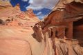
Coyote Buttes South, March 26, 2014
|
|
|
|
Coyote Buttes South lies within Paria Canyon-Vermilion Cliffs Wilderness east of Kanab, UT. Access is heavily regulated, with only 10 permits available by lottery four months in advance. 10 permits are issued to visitors through a lottery for hiking the following day; a total of 20 per day between the two lotteries. We lost out on the 'Wave' lottery (Coyote Buttes North) for which 120 hikers showed up for the ten available permits. Our luck was better for Coyote Buttes South; only 17 people hung around, vying for 10 permits. Interestingly, we did not see one of the twenty people holding permits the day we hiked Coyote Buttes South. The weather called for a 40% chance of showers with winds 16 to 26 gusting as high as 40 m.p.h.. That may have scared a few off, but adverse weather makes for interesting photos. We drove on difficult 4 wheel drive roads from White Pocket, directly into the heart of the South Buttes, from the east, entering at the Cottonwood Cove Trailhead. Most have a much longer hike in from the south, entering at the Paw Hole Trailhead, and an even longer hike if they are unable to reach that trailhead through the deep sands that require a high clearance 4-wheel drive. I was concerned we would get stuck in deep sand along the lateral road from White Pocket to Cottonwood Cove. Had I know we had reached the Cottonwood Cove parking area, I would not have driven the last 100 yards downhill through deep sand to the trailhead. The Chevy pickup, burdened with a camper, still managed to crawl out in low 4 wheel drive. This was beautiful hike, made better because we had the place to ourselves. We were glad we had marked the car with the GPS. It is surprisingly easy to lose one's bearings, even in daylight with map and compass!. We did a large clockwise cross country loop; there are not trails, and the blowing sand fills in any footprints.
39 files, last one added on Apr 05, 2014
Album viewed 9 times
|
|
|
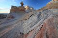
White Pocket, March 25, 2014
|
|
|
|
After spending all morning at the BLM in Kanab, UT, dealing with permit red tape, we managed to secure a permit for the Coyote Buttes South, but not until the next day. For the remainder of the day, we opted to hike into White Pocket, a remote area of deeply eroded sandstone exposing layers of richly colored rock strata just east of Coyote Buttes in the Vermilion Cliffs National Monument. Half the adventure was getting there on the sandy, 4-wheel drive only, backroads. At one point along the single lane road, we found a place to pull aside without getting stuck, to let an oncoming vehicle pass within inches of our mirror. Following close behind him was a group of almost twenty 4-wheelers who must have been part of a club outing. Aside from one other vehicle at the parking area, we saw no one else. We lost some valuable hiking time at the trailhead (what trail?) cleaning the mess of food, including salsa and broken eggs that had been ejected from our ice box onto the floor of the camper after careening over some nasty bump. The light only got better as the sun dropped toward the horizon.
27 files, last one added on Apr 14, 2014
Album viewed 7 times
|
|
|
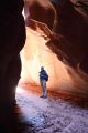
Buckskin Gulch, Paria Canyon, March 24, 2014
|
|
|
|
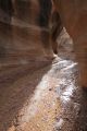
Located within the Grand Staircase-Escalante National Monument and Paria Canyon-Vermilion Cliffs Wilderness Area of southern Utah, this route descends the deepest slot canyon in the southwest United States and is purported to be the longest the world. Since we did not obtain two of the 20 overnight permits issued for that particular day by winning a lottery 4 months earlier, we opted to do the entire 21 mile loop in a day, starting at 8 am at Wire Pass, and finishing at White House Campground around 9:30 pm. Fortunately, the number of day hikers is not limited; instead, day hikers pay $6 each for the privilege of hiking anywhere in the canyon. Even a dog must pay! We wore trail running shoes/boots, until it became too wet, about one mile above the confluence of the Paria River, then put on neoprene socks and trail running shoes designed for water. I estimate we crossed the Pariah fifty times. Carry a headlamp!
154 files, last one added on Apr 01, 2014
Album viewed 19 times
|
|
|
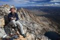
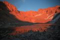
Thompson Peak, via Goat Lake, September 13, 2013
|
|
|
|
We came very close to cancelling this adventure as we watched the weather predictions deteriorate. Over the years, I have learned that inclement weather provides great photo opportunities. Predictions of snowfall later in the week convinced us to make our attempt at climbing Thompson Peak, the highest peak in the Sawtooth, this year before it was too late. So, with predictions of 70% chance of heavy rain that evening and the following day, we set out from Iron Creek trailhead at just after 4:00 pm, headed for meadows in the lake basin above Goat Lake.
101 files, last one added on Sep 18, 2013
Album viewed 21 times
|
|
|
|
|
Ten Lakes Basin via Pettit/Toxaway Loop, August 4, 2013
|
|
|
|
I had planned a cross country route into the Ten Lakes Basin from Twin Lakes on the Pettit/Toxaway Loop years ago, but never got around to trying it until now. We opted to reverse the xc route, using it as an exit instead. After seeing large trout on a day hike to Trailside Lakes earlier in the year, I decided I would also try something else I had put aside for many more years; my fly rod. I had read a report online describing fly fishing at many of the lakes in this area, and was inspired to visit most of them, including Edith, Edna, Vernon, Ardeth, Spangle, Ingeborg, those in the Ten Lake Basin, and Heart in the basin west of Snowyside Peak. This was an ambitious four day backpack, especially considering the weight we carried, which, as usual, included a DSLR and 3 lenses and too much food. Since I was learning to fly fish, we could not rely on catching dinner. My persistence was rewarded with a 13" rainbow at Heart Lake on our last evening.
79 files, last one added on Aug 19, 2013
Album viewed 22 times
|
|
|
Beartooth Mountains, August 15, 2012
|
|
|
|
The route we took on this trip was not carefully planned, but evolved as it went. Leo Hennessy suggested some places to visit in the Beartooths that offered maximum reward for minimum effort; my favorite kind of hiking. I plotted these lakes and peaks into my mapping program, then connected the dots. A loop took shape, that offered several options. The second day out, we met a group coming from the same direction we were headed. The plan evolved into something quite a bit more interesting; an alpine lake campsite higher than we planned, and the possibility of doing a 12000 plus peak, rather than just climbing a ridge. We encountered mountain goats, deer, a bald eagle, marmots, foxes, and fortunately, did not come face to face with any grizzlies. Driving home, we drove further east to Beartooth Pass, just shy of 11000'. We entered Yellowstone at dusk, and saw moose, buffalo, deer, wolves, and a grizzly bear. The entire trip proved more difficult than expected, taking much more time to complete the cross country travel than I had anticipated. That extra time caught up with us on the drive back, not arriving in Boise until 4:30 am Monday morning.
254 files, last one added on Aug 27, 2012
Album viewed 6 times
|
|
|
Evolution Basin, July 15, 2012
|
|
|
|
We were looking for a quick way into the Evolution Basin region of the Sierra Nevada that would allow us to do a loop. I have done Echo Pass several times, but much later in the season. That pass is described as class 3, ice axe required. I don't recall it being difficult, and I did not need an ice axe. I opted for an alternative rated class 2, because it was still early in the season, and my companion is not yet comfortable on terrain requiring the use of an ice axe. Besides, who wants to carry an ice axe for one short pitch on a 5 day trip? Wallace Col was a big mistake. Not only is it extremely loose and dirty, but it is steep! We did manage to get over it, though it took much longer than I anticipated, and once we descended into Evolution Basin, the cross country travel was exhilarating. We didn't see anyone else until reaching the hut on Muir Pass the next day, where we encountered about 5 other parties! After experiencing two evenings with incredible alpenglow, and an enjoyable climb of Mt. Solomons, we exited via Lamarck Col.
277 files, last one added on Dec 14, 2012
Album viewed 11 times
|
|
| 43 albums on 4 page(s) |
2 | |
|
|
|

IMG_9539.JPG2 views
|
|

IMG_4828.JPG5 viewsThere always seems to be a resident Marmot at the top of a well traversed summit. It doesn't seem to matter that there is no apparent source of water up here, other than potholes of rapidly evaporating water collected during that last thunderstorm.
|
|

DSCF0687.JPG5 viewsCrossing the meadow due south and well above Ocalkins Lake. It appears that the stream is flowing beyond those trees ahead. I should be able to find water without going out of my way.
|
|

IMG_7073.JPG1 viewsPolarized low angle light from the side creates a surreal effect; Hummock Lake.
|
|

IMG_6485.JPG4 views
|
|

DSCF0877.jpg5 viewsThis is where I came upon the main trail leading me back to Imogene Lake last night. I stayed closer to the trees to avoid getting my feet wetter than they already were. Note Finger of Fate, the obvious pinnacle on the right skyline. About a mile below Hell Roaring Lake I lost the light. I stopped, had a big snack, put on some pants legs, polartec pullover, mountain parka, gloves, headlamp, and swapped visored cap for balaclava. I enjoyed a pleasant stroll down to the Stanley Valley, arriving at my car at 10 pm. Just a wonderful fall backpack!
|
|

DSCF1046.JPG1 viewsCloser (200 mm) on the previous day's descent route; the 'cheese grater'. Again, I prefer the solid rock to the scree trails. Solid handhold on steep terrain offer so much comfort.
|
|

IMG_9528.JPG0 views
|
|
|
|

DSCF1097.JPG2 viewsThis tarn is at an elevation of 9730', well above Fourth of July Lake. The water is a bit brackish, but will do in a pinch. I hear from more than one party ascending from the Fourth of July trail head that the road from Stanley to Grandjean was is still closed. I'm making good time, and will be able to make the most of the remaining light, getting to Ketchum just as it is getting dark. I reach the trail head at 7:30 pm, completing the "epic White Cloud backpack loop" for the fourth time.Sep 09, 2024
|
|

DSCF1095.JPG2 viewsFourth of July Lake to the S.Sep 09, 2024
|
|

DSCF1094.JPG4 viewsDescending toward Fourth of July Lake from the top of the ridge SW of Ants Basin, looking W across the Sawtooth Valley. One can see the smoke from the Wapiti fire S of Stanley on frame right (N). Yesterday I was told the road from Stanley to Grandjean was still closed. I'm hoping that has changed, but not counting on it.Sep 09, 2024
|
|

DSCF1093.JPG1 viewsShadows drifting across the face of WCP-8 (10557') from the top of the ridge SW of Ants Basin. (58 mm)Sep 09, 2024
|
|

DSCF1089.JPG2 viewsThe familiar orange band I navigated toward the first day to the trip descending Strawberry Basin to Warm Springs Creek from the top of the ridge SW of Ants Basin. (200 mm)Sep 09, 2024
|
|

DSCF1087.JPG1 viewsWCP-8 (10557') from the top of the ridge SW of Ants Basin. (95 mm)Sep 09, 2024
|
|

DSCF1086.JPG1 viewsThe pinnacle immediately S of the Devil's Staricase from the top of the ridge SW of Ants Basin. (200 mm)Sep 09, 2024
|
|

DSCF1084.JPG1 viewsWCP-8 (10557') above the Warm Springs Creek drainage. The constantly changing light and shadow drifting across the limestone face provide photo opps.Sep 09, 2024
|
|